How to use this blog...

This blog allows you to explore some archaeological themes, periods and places. You can do this by: clicking the dates on the left to select particular posts; enter a term (e.g. Newgrange) in the search box below; scroll down and visit the Archaeology News section on the left.


Search This Blog

Horizontal Mills in Ireland

HORIZONTAL MILLS
Horizontal mills exploit water power for various tasks. Today we are still familiar with similar methods of harnessing energy using water power as waterwheels are still in use.
Generally speaking, a horizontal mill has a 'horizontal' wheel which water is channelled on to via a system of races controlled by a sluice gate. The wheel turns an axle which is attached to a grinding stone or a gear mecchanism of some sort.
Various writers at the end of the Middle Ages describe and illustrate the machinery found in a horizontal mill.
These include Ramelli's 1588 Les Diverse ed Artificioso Machine and Georgius Agricola's De Re Metallica (from 1556). A diagram of a relatively modern mill can be viewed here.

The terminology is also known from medieval sources in Italy as outlined here.

The extensive excavation of an early medieval settlement at Raystown, Co. Meath produced a complex of mill streams and mills.

As can be seen in this image, the base of a mill contains the undercroft with the horizontal wheel and some sort of pivot to keep the axle vertical. The superstructure has normally rotted away long ago and is no longer visible. The wheel has a series of paddles or vanes attached that are hit by the water which enters the undercroft via a flume and drives the wheel around.

Vertical watermills are also known, where the wheel is set upright and is around driven by water hitting the paddles at the bottom (known as undershot) or top (called overshot). At Nendrum, in County Down, a mill was excavated where the water was retained in a mill pond at high tide. This type is known as a tidal mill.

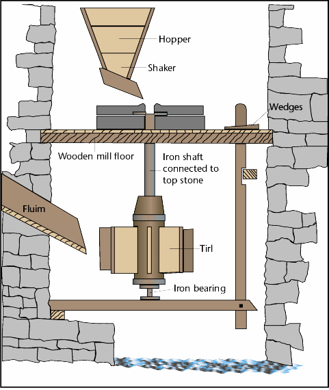
Milling terms in early Irish texts are also known from various sources in Ireland and Scotland and are summarised here: Mac Eoin, G. (1981) The early Irish vocabulary of mills and milling, in Studies on Early Ireland, 13-19. An diagram from Mac Eoin's paper is shown below.


Linear Earthworks in Ireland

Linear Earthworks are found in Ireland that largely date to the Iron Age.

They tend by visible as earth banks with an accompanying ditch or as a pair of ditches running for great distances across the countryside.

Such linear earthworks are generally only well preserved for short stretches and the best known examples are:
Doon of Drumsna, Co. Roscommon, the Dorsey, Co. Armagh, Black Pig’s Dyke in Counties. Armagh, Monaghan, Cavan and Leitrim; Worm’s Ditch – another name for Black Pig’s Dyke; the Dane’s Cast in Co. Armagh and Co. Down and An Claidh Dubh which survives in various sections over a very large area of Cork and into Limerick. There is also an earthwork called An Claidh Ruadh in Co Kerry and Co Limerick.

Their purpose and function are unclear. They may have indicated some sort of territorial boundaries, acted as
obstacles to cattle rustling or some other use that is not clear today. Broadly speaking they all date to the Iron Age.

Excavations at the Doon of Drumsna in Co. Roscommon showed that it dates to 400-100 BC.

The complex around the Dorsey, Co. Armagh and the Black Pigs Dyke and Worms Ditch all appear to be part of the same earthwork. Excavations have repeatedly produced Iron Age dates mainly falling between 150 and 90 BC.

The Dane’s Cast in Co. Down has never been investigated and it is unclear whether it is Iron Age or possibly medieval as it is somewhat similar to the late medieval Pale Ditch around the English enclave at Dublin.

Investigations of An Claidh Dubh also suggest that it dates to before 100 AD.

For more click here.

Viking expansion into Ireland and beyond

Viking Expansions into Ireland and beyond

Forget the old story about vikings carousing the seas looting and pillaging.
In the centuries before the vikings began to expand across the Atlantic, there were 'early medieval emporia' in place around the Irish coast that appear to have been the main contact points for traders bringing goods into Ireland (and Scotland). Whether this was because of a perceieved taboo over dealing with foreigners (a way to both keep out disease and protect your own position by ensuring only you get to meet them).
A probable example was found on Dunnyneill Island, County Down and another example is a site like Dalkey Island.
Finds include exotic objects like pottery imported from the area of the former Roman Empire like E-ware and glass.
From the eighth century AD onwards, houses and objects typical of Norway and other parts of Scandinavia begin to appear in the Northern and Western Isles of Scotland and down into the Irish Sea area, at sites like 
Underhoull in Shetland and Hamar also on Shetland.
Excavations south of Dublin at Cherrywood found objects that suggest Norse settlement near Loughlinstown which actually means 'the town of the Lochlainn' - Lochlainn is a word used by the Irish to refer to the Norse. Some of the structural remains suggested that, in an early phase, a longhouse had been built on the site.The large enclosure in which the site was built was much earlier in date and had been used for burials in the 6th-7th century AD. It was then abandoned but apparently re-used in the 9th century AD when the first of several phases of structures were built. The longhouse (see the various structures shown on this plan) is dated by its position within the sequence of occupation at the site.
The earliest identified phase was the enclosed cemetery in the sixth/seventh century AD. Structure 4 dated to 680-890 AD and Pit (F535) was dated to the late ninth century AD or slightly later, based on a fragment of a whale bone plaque which was present. Structure 1, the possible longhouse, dated to before 1020-1190 AD. A kiln, dated by burnt oats to 1020-1190 AD was followed by two further structures, Structures 2 and 3, probably dating to before 1020-1230.
Many of the finds do not necessarily imply anything about the occupant's identities as they would be typically found on an Irish or Norse site of the same date. The whale bone plaque is typical of finds associated with Norse woman, such as this one from Orkney. A fragment of a similar object was recovered from the Norse graves found in Kilmainham near Dublin city centre.
One of the structures at Cherrywood was similar to buildings erected by the Norse in the urban centres of Ireland around the same date. The finds, though, are equally typical of contemporary rural Irish sites.
For more about Cherrywood click here .
A similar structure was found at Llanbedrgoch, Anglesey in Wales showing that, in this period, the Norse maintained contact with the scattered Norse communities around the Irish Sea and beyond.

Another find from Cherrywood, a silver ingot, while unprovenanced, represents one of the reasons why the Norse are important in Ireland’s links to the outside world – the silver trade - one of the possible reasons that the Scandinavians continued to spread around Europe re-establishing trade routes from the Mediterranean up into Northern Europe. Eventually they also began to explore the seas to the west.

The Vinland Sagas
Two short Icelandic Sagas discuss the settlement of Greenland the first voyages to the New World:
Saga of the Greenlanders (Grænlendinga saga).
Eirik the Red’s Saga (Eiríks saga rauða)
Both sagas refer to events 970-1030 A.D., and both were composed much later, 1220-1280 A.D.
The sagas were written independently and record oral history – unlike Njal’s Saga, there was little if any literary reworking, reshaping or editing.
(Njal’s Saga dates from the 13th century and describes the progress of a series of blood feuds. Its author is believed to have lived in southeast Iceland and the events occur between 960 and 1020).

Both sagas contain many of the same details, though the elements are recast into a different sequence or placed into a different context.
Fanciful and legendary elements in the sagas caused them to be rejected by historians until Helge Ingstad and Anne Stine located the remains of Viking settlements at L'Anse aux Meadows in Newfoundland in 1960.
Artifacts from excavations there proved that Norsemen had reached Canada c. 1000 A.D.
Both sagas deal with other events as well, especially with the settlement of Greenland and with the conflict between the Heathen and Christian religions.
The settlement on Vinland was short-lived, lasting only a few years. Conflicts with the natives (Skraelings) probably hastened its demise.
The settlements on Greenland lasted from 985 to 1350 (Western Settlement) and to c. 1480 (Eastern Settlement). The cause of abandonment is unclear and has been discussed by various authors including Jared Diamond in Collapse.
The Greenland settlement was not entirely self-sufficient. Marginal land was used for raising sheep during the medieval warm climate which meant that cold snaps and periodic shift in temperature threatened the available grazing and size of flocks.They had also become Christianised (this is Hvalsey church) and some of their cultural practices, defined by their religious observance and Christian morals, were expensive and difficult to maintain in such an environment.
The real attraction of Greenland was the hunting, especially for arctic specialities walrus (ivory), polar bear, gyrfalcons etc., which were prized luxury items on the continent.
Some trade took place with the natives, although the Greenlanders were never able to establish the same relationship they had with the Sami, for example.
Helge Ingstad (1899-2001) unearthed the ruins of an ancient Norse village near L’Anse aux Meadows on the north coast of Newfoundland, conclusively proving that the Vikings has established a settlement in North America 1000 years previously.

A.D. 990, Leif Eriksson, son of Erik the Red, exploring to the west, finds and names several new areas:
Slabrock Land-Baffin Island
Forest Land-Labrador and Newfoundland
Wineland-Northern Maine/New Brunswick.
Came into contact with "wild groups" of people.
His brother, Thorvald, was killed by natives and buried near the Bay of Fundy.
At L’Anse Aux Meadows, around 1000 AD, 8 sod wall houses were occupied by the Norse.

There are many theories as to the fate of the Greenland and American Vikings.

Navan Fort

Navan Fort, Co. Armagh
Navan Fort is one of a complex of monuments located to the west of Armagh city. The main mound and enclosure are open to visitors.
This area features in mythology such as the Táin Bó Cuailgne (Cattle Raid of Cooley) and other tales involving Cú Chulainn. In this tales the site is referred to as Eamhain Macha. This had indicated that the site had significance in the early medieval period but its prehistoric importance was unproven.
Believed to be indicated on Ptolemy’s Map (possibly based on 2nd century BC sources) as ‘Isamnion’ which is an earlier form of ‘Eamhain’ (from which it is derived by syncopation – with syllables being lost: I(s)AM(ni)ON becomes IAMON, or Eamhain).

Modern intensive research has indicated that a number of sites are present in the area including Haughey’s Fort, a Late Bronze Age hillfort. A number of sections were excavated across the lines of the ramparts by Prof. Jim Mallory of Queen's University Belfast (see various papers in the journal Emania).
Only the ditches survived as no traces of banks were recorded. The ditch was waterlogged allowing for the survival of wooden finds and other organic material. Traces of three concentric ditches have been recorded, although it is not clear if each completed a full circuit.
Investigation of the interior produced evidence of various pits and postholes suggesting there were structures within the innermost ditch.
Finds from the interior include bronze rings, a gold stud and a fragment of the handle of a decorated bronze vessel.There was also a stone with rock art from pit in the interior.
Other sites in the Navan complex include the King’s Stables, an artificial pool of similar date to Haughey's Fort.
At Tamlaght, at the edge of an area of swamp, a hoard of an Irish Late Bronze Age sword and two central European sheet bronze vessels was found.
Navan Fort itself was excavated by Dudley Waterman 1963-72, later by Jim Mallory and Chris Lynn
The overall diameter of the main enclosure is 286 m and a  number of internal sites are visible: Ringditch (Site A) and Mound (Site B). Geophysics indicated a 30 m diameter double circle (between Sites A and B), known as Site C.
The morphology of the enclosure is unusual in that the bank is on the outside of the ditch. This is typical of other sites of similar date (Iron Age) and status (remembered as 'royal' sites in the 7th and 8th century AD).
Jim Mallory carried out excavations on the site in the late 1990s and and found an oak that dated to 95 BC.

Site A
Excavation indicated a complex history (see here for plans etc).
Basic Phasing:
(Phase A) – a series of structures with concentric slot trenches (diameters 16.6 m, 18.8 m and 20.3 m), postholes survive in the inner slot. No evidence of entrance. Associated finds include coarse pottery, charcoal suggested a date of 4th century BC to 1st century AD.
(Phase B) - again structures with concentric slot trenches, with a 2 m wide gap. Entrance to the east, large central posthole – slots and posthole cut outer slot of Phase A structure but not the inner slots – part of the same building as the inner slots or a later feature?
Two extended inhumation burials outside the Phase B structure, one in a nailed coffin and are no doubt later in date.

A 5.5 m wide and 2 m deep ditch was opened across site A, enclosing an area 37 m in diameter, with some traces of an external bank. A terminal of a bronze brooch of 9th/10th century AD was recovered from 0.90 m above the base of the ditch.

Site C
This was subsequently investigated by Chris Lynn in 2001.

Site B
Phase 1: scatters of pottery, flint, three polished stone axe fragments.
Phase 2: episode of ploughing
Phase 3: three subdivisions (Phase 3i; 3ii; 3iii).
3i: circular ditch, 5 m wide and 1 m deep, enclosing an area 45 m in diameter (cobbled causeway to the east). Large ring of posts, 4 m apart, 4-5 m inside the line of the ditch. Available dates are 1600-1200 BC for the posts and 900-550 BC for the ditch.
Phase 3i: circular ditch, 5 m wide and 1 m deep, enclosing an area 45 m in diameter (cobbled causeway to the east). Large ring of posts, 4 m apart, 4-5 m inside the line of the ditch. Available dates are 1600-1200 BC for the posts and 900-550 BC for the ditch.Phase 3: three subdivisions (Phase 3i; 3ii; 3iii).
Phase 3ii: complex sequence of timber structures.
Phase 3iii: last set of ring slots, date 200-95 BC.
Finds from Phase 3 include sherds of coarse ware, shale armlets, glass beads, a bronze bar toggle, a fragment of a winged chape, part of a socketed bronze sickle, a tiny socketed bronze axe and a bronze pin with a spiral-ribbed head; clay mould fragments, iron objects, ring-headed pin, and a Barbary Ape skull (ring slot C2., dated to 390-20 BC).
Animal bone: twice as much pig as cattle, little sheep or goat.
Phase 4: A 40 metre circular structure was erected (the central post was dated to 95-94 BC).
Phase 5: A mound of stones was erected over the 40 m structure.

Navan Fort has broad parallels with sites like Knockaulin (Dun Ailinne) which was excavated by Bernard Wailes (see here). Also features at Tara and Rathcroghan.

Angles, Saxons, Normans ...

Angles, Saxons, Normans …

Britain from Rome to the Normans
Just prior to the Visigoth sack of Rome in 410, Roman troops were withdrawn from England (408).
Angles, Saxons, and Jutes then invaded the British Isles.
This was an age of many kings, but no king of England.
Sometimes a given king would have great power over other kingdoms—such as Aethelberht, King of Kent.
Seven major Kingdoms emerge (often referred to as the Heptarchy).

These non-Roman 'barbarians' – Saxons, Angles, and Jutes – are depicted as invading Britain by sea in the fifth century in the Passion of St Edmund.
Gildas writing in the 6th century (see De Excidio Britanniae), described the collapse of Roman power and the arrival of mercenaries in the 5th century.
Bede wrote a history of 8th-century Anglo-Saxon kingdoms (Historia Ecclesiastica Gentis Anglorum):
‘Those who came over were of three of the more powerful peoples of Germany: the Saxons, the Angles and the Jutes’
Thus Jutes, Angles, Saxons and Frisians arrived in the fifth century, with Anglo-Saxon kingdoms emerging in the seventh century.

The Undley Bracteate is a 5th century find from Undley Common, Suffolk.
It is the earliest known inscription in Anglo-Frisian ‘Futhorc’ (as opposed to ‘Futhark’).
The image is Contantine the Great with Romulus and Remus suckled by the wolf.
Futhorc, like Anglo-Saxon runes and Germanic ‘Elder’ runes and ‘Younger’ runes were generally replaced on Christianisation.

The Angles came from Angeln (according to Bede their whole tribe came)Saxons from Niedersachsen
Jutes from Jutland
Also smaller groups of:
Frisians (their name survives in placenames like Fresham, Freston, Friston)
Flemings (as in placenames like Flemby, Flempton)
Swabians (apparently their name survives in the placename Swaffham)
Franks (whose name survives in placenames like Frankton, Frankley)

Angles, Saxons, Jutes etc...
These groups may be coeval with the Ingvaeones, as described in Tacitus's Germania, (AD98), a West Germanic cultural group living in the Jutland, Holstein, Frisia and the Danish islands.
The postulated common group of closely related dialects of the Ingvaeones is called Ingvaeonic or North Sea Germanic.
Major issues
Origins of ‘the English’: debate and discussion – several theories tend to dominate.
Was there massive invasion & migration?
Or, a takeover by small powerful groups?
Or, a slow transformation as people abandon ‘Roman’ ways, and adopt Anglo-Saxon customs?

The building shown below is a typical Anglo-Saxon ‘grubenhaus’
Contact and Migration
Finds of silver sceattas of the porcupine-standard series attributed to mints in Frisia
The sceats here are 7th century (right and below) and 8th century (below right)
Continuity ...
But, also much archaeological evidence for continuity of British ways such as building styles
Cowdery’s Down, Hants
Highdown, Sussex
Highdown in use as a cemetery by [pagan] Saxons, including a mixture of inhumations and cremations placed in urns
At the same time a Romano-British villa at nearby Northbrook, less than a mile away, was still in use by native Christians.
Anglo-Saxon architecture
Earliest surviving architecture is 7th century.
In the north of England, churches are narrow with square ended chancels.
In the south, churches had apsidal ends separated from the nave by a triple arch opening, for example at Reculver.
Anglo-Saxon architecture
Apsidal church from Brixworth (Northamptonshire)
Arch similar to Reculver at entrance to the apsidal end

Anglo-Saxon architecture
The most complete example of the northern type of church is at Escomb (Durham).
Old Minster, Winchester
Constructed in 648 for King Cenwalh of Wessex and Saint Birinus, diocesan cathedral by 660.
Saint Swithun buried outside it in 862.
New Minster built next to it (901), Saint Æthelwold of Winchester followed by his successor, Saint Alphege, almost completely rebuilt the minster on a vast scale during their monastic reforms of the 970s.
Old Minster demolished in 1093.
ANGLO-SAXON HEPTARCHY
Major kingdoms:
Northumbria
Mercia
East Anglia
Essex
Kent
Wessex
Sussex
Minor kingdoms:
Hwicce
Magonsaete
Kingdom of Lindsey
Middle Anglia
ANGLO-SAXON HEPTARCHY
Major kingdoms:
Northumbria
Mercia
East Anglia
Essex
Kent
Wessex
Sussex
Minor kingdoms:
Hwicce
Magonsaete
Kingdom of Lindsey
Middle Anglia
Laws of Aethelberht
Laws of Aethelberht
Sutton Hoo
Two Anglo-Saxon cemeteries of the 6th century and early 7th century, one of which contained an undisturbed ship burial.
Use of the site culminated at a time when the ruler (Raedwald) of East Anglia held senior power among the English people, and played a dynamic (if ambiguous) part in the establishment of Christian rulership in England.
The ship-burial probably dates from the early 7th century and was excavated in 1939.


Sutton Hoo


Anglo-Saxon Art: Fuller Brooch
Late 9th century brooch, found in Normandy.
11.4 cm disc of hammered sheet silver inlaid with black niello.
The centre is decorated with the five senses.
In the middle is Sight
Taste (top left)
Smell (top right)
Touch (bottom right)
Hearing (bottom left)
The outer border consists of humans, bird, animal and plant motifs.
Unusually it does not represent divinity.
Anglo-Saxon Art: Manuscripts
Illuminated Anglo-Saxon manuscripts survive, such as the Benedictional of St. Æthelwold and Leofric Missal drawing on Hiberno-Saxon art, and, Carolingian and Byzantine art for style and iconography.
Combines northern ornamental traditions with Mediterranean figural traditions.
Anglo-Saxon Art: Manuscripts
Dates between 963 and 984. Contains a Latin inscription which describes how it was made:
A bishop, the great Æthelwold, whom the Lord had made patron of Winchester, ordered a certain monk subject to him to write the present book . . . He commanded also to be made in this book many frames well adorned and filled with various figures decorated with many beautiful colours and with gold. This book the Boanerges aforesaid caused to be indicted for himself . . . Let all who look upon this book pray always that after the term of the flesh I may abide in heaven Û Godeman the scribe, as a suppliant, earnestly asks this…

West Stow
Hamlet of West Stow, Suffolk
Occupied during the 5th–7th centuries
5 acres excavated – 1960s & 1970s
7 larger house = family halls? c.12m long; hearth; S. side door
60 Sunken-featured buildings (grubenhauser)
West Stow: finds
Yeavering, Northumbria
Anglo-Saxon villa and royal palace – earliest known (Bede: Ad Gefrin)
Identified 1949 aerial photography
Excavated 1950s & 1960s by Brian Hope Taylor
Great enclosure: circular entrance works – a corral for animals?
Archaeological evidence for fire – all buildings burnt to the ground (in AD633: King Edwin killed; massacres in Northumbria).

Yeavering, Northumbria
Bronze Age burial mound with large upright pole: Focus for pagan Anglo-Saxon burials? Building aid?
The Great Hall: 7th century. Massive timbers, communal centre: Feasting, music, singing, royal ceremonies
Area ruled but not peopled by Anglo-Saxons?
Theatre: cuneus
Unique in A-S England
Triangular stepped structure w/ stage
Performance, assembly?

Alfred the Great (871-899)
King of Wessex who wielded power over all of so-called ‘Heptarchy’ (see language map)
Defeats newest arrivals (Danes)
Issued a Code of Laws for all the realm
Began the English Navy
Commissioned the Anglo-Saxon Chronicle (often taken as a measure of the stability of his reign)

From Alfred to William, 899-1066
Alfred’s successors were not great rulers—Ethelred the Redeless (stupid), for example—and the Vikings under King Cnut actually assumed control of the realm.
Cnut’s successor had no heirs and created a question of who would become king
3 candidates: Harold Hardrada, Harold Godwinson of Wessex, William, Duke of Normandy
William wins Battle of Hastings, October 1066
Feudalism
Social contract between ‘lords’ and ‘vassals’
Theoretically it is reciprocal (see diagram)
In practise in had centralising tendencies
Became the dominant political system in Europe
Becomes synonymous with the Normans
What did it replace??
Viking Towns
York, Birka, Hedeby, Dublin
Based on trade
Chattels not real estate
Dublin


1000 AD
Dublin, 1170
William I—King of England (1066-1087)
Introduced Norman Feudalism into England—emphasized power of King (Salisbury Oath)
Domesday Survey
Much central authority compared to earlier governmental arrangements in England

Great Council created out of Witan
Curia Regis established
But who were these ‘Normans’??
Bayeux Tapestry, c. 1073-1088
Willliam and Harold
Battle
William’s Feast
Normans?
Normandy is approximately the same region as the old church province of Rouen
Was sometimes called Brittania Nova and western Flanders.
No natural frontiers and was previously merely an administrative unit.
Viking settlers begun arriving in the 880s, divided between a small colony in Upper (or eastern) Normandy and a larger one in Lower (or western) Normandy.

Rollo
In 911 AD Charles III of France gave Normandy to the Viking leader Rollo who became a Christian. Vikings helped adopt the French language and organized a strong state in Normandy.

Rollo’s grave, Rouen
Rollo
Passed title to his son in 927 before his death.

Normandy
From the 10th century the Norse settled and adopted the language and culture of the French majority.
After a generation or two, the Normans were generally indistinguishable from their French neighbours.
In Normandy, they adopted the growing feudal doctrines of the rest of northern France.
The old French aristocracy could trace their families back to Carolingian times.
The Normans knights rended to remain poor and land-hungry.
By 1066, Normandy had been exporting fighting horsemen for more than a generation.
Prior to 1066 and then crusades knighthood before the time of the Crusades held little social status.

Mottes
Illustrated on the Bayeux Tapestry
Mottes
Illustrated on the Bayeux Tapestry
Mottes
Illustrated on the Bayeux Tapestry
Mottes
Bayeux Tapestry showing the motte at Hastings being built.
Architecture and the early Normans
There was a resurgence in the development of distinct architectural styles under Charlemagne.
Palace Chapel of Charlemagne, Aachen, 792-805
Monasteries
Designs for the monasteries had already been drawn up under order of Charlemagne
Developed a role as cultural/learning centers
St. Gall
Abbey at Cluny, begun 910
French monastery, Benedictine monks
Largest, most powerful monastery, 10th-12th c.
Early Christian vs. Romanesque
This is the difference in effect of a barrel vault (on the right) and the pre-existing style of roof.
Cluny
Three main phases from 910 onwards (coinciding with the emerging Norman state).
The greatest monastic Romanesque church, Cluny III (1088-1121), did not survive the French Revolution but has been reconstructed in drawings
Double-aisled church almost 137 m long, with 15 small chapels in transepts and ambulatory
Its design influenced Romanesque and Gothic churches in Burgundy and beyond, often coinciding with the spread of liturgical practices under Norman influence
Cluny III
3rd Abbey Church at Cluny
Largest church in the Christian world
Vertical emphasis
3rd Abbey Church at Cluny, 1049
Largest church in the Christian world
Like Roman basilica but more elaborate
Established ‘Romanesque’ style.
3rd Abbey Church at Cluny, 1049
Vertical emphasis was possible as the churches had very thick walls
The vault was constructed as a series of arches with the wight carried by the large pillars.
St. Sernin, c. 1080
France led the way in the development of Romanesque.
Typical Romanesque Church Plans
St. Etienne, c. 1067-1135
Romanesque
The term “Romanesque” itself was first used in the 19th century. The word Romanesque originally meant "in the Roman manner.“
Use of the Roman round arch, adoption of the major forms of antique Roman vaulting (contained, strong, weighty and somber style)
Most Romanesque churches retained the basic plan of the Early Christian basilica: a long, three-aisled nave intercepted by a transept and terminating in a semicircular apse crowned by a conch, or half-dome
European movement in architecture (10-12th centuries), especially in Italy, France, England and Germany

St. Etienne, Romanesque Facade
Plain
Divided into three sections
Squat
Massive

Tower of London, c. 1078-1097
Most famous Romanesque building in Britain?
Tower of London, c. 1078-1097
The interior features all shown Romanesque influence:
Round-headed windows
Round thick pillars
Barrel-vault
St. Etienne, Romanesque Facade
Plain
Divided into three sections
Squat
Massive

Tower of London, c. 1078-1097
Sculpture as Church Decoration
La Madeleine, Vezelay, France
c. 1120-1132
Tympanum
Narthex


Manuscript paintings as inspiration for sculpture
La Madeleine, capitals
Romanesque Painting-Illuminated Manuscripts

17th Century and Industrial Revolution

Seventeenth Century and Industrial Revolution
Seventeenth century Ireland
Bartletts map from 1602.
Ireland enters the 17th century in a state of war.
This is to set the tone for much of the century.

The Rise of Europe & Imperialism con’t
Until 18th century, Europe lagged behind Asia and parts of Africa in economic development.
2 groups of factors set stage for modern economic growth and socio-political change
300 years between 14th and 17th centuries
Renaissance and Enlightenment (eventually leading to industrialisation)
European geographical expansionism

The Rise of Europe & Imperialism
Geographical Expansionism
seen as the mercantile phase of Imperialism
Enormous profits from seafaring and conquests
exploitation of technological backward non-European people (ideological justified as ‘civilising mission’)
Slave trade; Spice trade; Precious metals; exotic goods. Atlantic trade. Footholds established.
New expressions of wealth
Ole Worm’s Cabinet of Curiosities, Denmark 1655

The new found European success opens up the opportunity to collect exotica as way of illustrating the breadth of connections, wealth and power.
The Rise of Europe and Imperialism
Mercantile Imperialism
primitive accumulation (Marx);
booty capitalism (Weber);
superiority of force of Europeans “… enabled to commit every sort of injustice in those remote countries” (A. Smith).
European Renaissance & Enlightenment had created an explosion of intellectual, scientific and artistic achievements; leading to political ideas and change by the seventeenth century.
The Rise of Europe and Imperialism
During 300 years:
no significant change in European economy and society
wealth used to fight wars;
Intensifying mercantilism to raise revenues for warfare.
Also leads to extravagant consumption.
Consumption?
Versailles (Pierre Patel 1668).
Hunting Lodge built by Le Roy in 1631 (Louis XIII).
In 1661, Louis XIV had a huge rural retreat built here, with the most extensive gardens in the world.
By 1682, he moved his court to Versailles.
English Palladian Architecture
Queen’s House, built by Inigo Jones 1614-17 for Anne of Denmark (wife of James I) at Greenwich (beside the Palace of Greenwich).
His first building in a ‘Palladian’ style following his tour of Italy.
Introduced a classical style to English architecture.
Queen’s Palace Greenwich
This is one of Jones original plans for the façade.
The work was completed in 1635
Classical Architecture
Ground plan of the original Queen’s House (the first storey is on the right of the diagram).
Only really hosted the court until 1642 when the culture it was designed for largely disappeared in England.
Palace of Whitehall
London home of English monarchs from the 16th century.
Under James I a new Banqueting House (1619-1622) was built to a design by Inigo Jones at a cost of £15,618.
Its decoration was finished in 1634 with the completion of a ceiling by Sir Peter Paul Rubens, commissioned by Charles I (later executed in front of the building in 1649).
Jones and the Banqueting Hall
Jones confirmed his re-invention of classical architecture in England with the building.
He was heavily influenced by Italian architecture and ignored existing Jacobean forms.
Jones proposed re-design of Whitehall
Charles I commissioned a complete re-design from Jones in 1638 to incorporate the Banqueting Hall and to be built in the same style.
Ultimately, Charles could never resource the project adequately.
Rathfarnham
Plan of castle built by Archbishop Loftus in 1590.
Note the defensive features such as the corner towers (Loftus lived at the Palace at Tallaght when it was sacked in 1589).
The buildings still owe much to traditional medieval architectural styles.
Classical Architecture
A fire destroyed the rambling Palace of Whitehall in 1698 and the Banqueting Hall was one of the few buidlings to survive (see Peter Paul Ruben’s ceilings).
While the classical style was viewed as Royalist, following the Restoration (post-1660) it was the favoured building style in England.
Backdrop to these developments?
The Wars of Religion, France (1562-1598)
End with Huguenots gain political equality of sorts.
Catalonia (to 1640s)
Revolts against Spain and Barcelona, Portugal tries to regain independence from Spain
The Fronde revolts in France (1648-1653)
Messes in the Netherlands (to 1640s)
Originally a revolt against Spain, the Netherlands got drawn into the shifting allegiances of European politics
The English Civil Wars (1625-1649)
The Thirty Years War (1618-1648)
Ended in Peace of Westphalia (modern diplomacy)
The emerging modern world: Tulips!
Introduced to Europe in the mid-16th century from Ottoman Empire.
Started 1593 when botanist Charles de l'Écluse had taken up a post at the University of Leiden and demonstrated that tulip bulbs would grow in the Netherlands.
Became a luxury item, classified in groups; one-coloured tulips of red, yellow, or white were known as Couleren, but it was the multicoloured Rosen (red or pink on white background), Violetten (purple or lilac on white background), and, to a lesser extent, the Bizarden (red, brown or purple on yellow background) that were the most popular.
The Tulip Bubble
In 1634 the rage for tulips among the Dutch was so great that the ordinary industry of the country was neglected, and the whole people turned to the production of tulips. As this mania increased, prices increased with it, until in 1635 merchants were known to have spent $40,000 in the purchase of forty tulips.
The Semper Augustus
A Semper Augustus, weighing only 200 grains, was thought to be cheap at $2200.
An inferior plant would readily sell for $800.
When first known, in 1636, there were only two roots of it in Holland: one belonged to a dealer in Amsterdam, and the other was owned in Haarlem.
One person offered twelve acres of valuable building land for the Haarlem tulip.
That of Amsterdam was sold for $1840, a new carriage, two gray horses, and a complete suit of harness.
Tulip-mania
A bill of sale for one single root of the Viceroy species:

Anatomy of a bubble
The demand grow until 1636.
Regular marts for their sale were opened on the Stock Exchange of Amsterdam, and at Haarlem, Leiden, and other places.
Symptoms of gambling and of time sales soon became prevalent every where. Stock-jobbers dealt largely in tulips - at first every thing rose and every body gained.
Tulip jobbers gambled on the rise and fall of bulbs, making large profits by buying when prices were low and selling when they rose.
It was believed that this mania would spread to other lands.
Nobles, citizens, farmers, mechanics, footmen, and even chimney-sweeps dabbled in tulips. Houses and lands were offered at ruinously low rates that their proceeds might be invested in bulbs that were expected to return a golden crop.
The prices of the necessaries of life rose, and houses and lands, horses and carriages, and luxuries of every sort rose with the rise of tulips: all commerce rested on a flower bed.
The Collapse
In 1636, the Dutch created a type of formal futures markets where contracts to buy bulbs at the end of the season were bought and sold.
Traders met in "colleges" at taverns and buyers were required to pay a 2.5% "wine money" fee, up to a maximum of three florins, per trade.
Neither party paid an initial margin nor a mark-to-market margin, and all contracts were with the individual counterparties rather than with the exchange.
No deliveries were ever made to fulfill these contracts because of the market collapse on 5th February 1637.
Banking
Banking continued to develope in the 17th century.
In England, commercial lending of money became more important.
Previously goldsmiths lent and changed money until, in 1640 King Charles I confiscated gold, which London merchants had deposited at the mint for safety.
Afterwards people began to deposit money with goldsmiths who gave receipts for the gold in the form of notes promising to pay on demand.
Banking
Governments needed to borrow, especially in wartime, often from wealthy individuals and later repaid them with interest from taxation.
However at the end of the 17th century the cost of fighting a war with France was colossal. So in 1694 the Bank of England was founded to provide a loan to the government.
A group of financiers put up £1.2 million. In return the bank received 8% interest on the loan and the right to issue notes. The Bank of England was also allowed to lend money and to buy and sell gold.
Rising Costs of Warfare: Artillery
The combining of shot and powder into a single unit, a cartridge, occurred in the 1620s with a simple fabric bag.
Gustavus Adolphus is identified as the general who reintroduced cannon to the battlefield - pushing the development of much lighter and smaller weapons and deploying them in far greater numbers than previously. But the outcome of battles was still determined by the clash of infantry.
Fixed fortifications were obsolete unless heavily fortified and defended.

Development of Artillery Fortifications
Marquis de Vauban, adviser to Louis XIV, major figure in late-17th century development of artillery fortifications.

Galway, 1651
Proper artillery defences required significant expenditure in the sevententh century.
Draught of proposed citadel at Dublin in 1685, by Thomas Phillips
Draught of proposed citadel at Belfast (also 1685), by Thomas Phillips
Development of Artillery Fortifications
Charles Fort, Kinsale
Built after 1677, incorporates latest styles of defences.
Charles Fort, Kinsale
Phillips plans show how quickly these forts were being elaborated.
August 1691
Seventeenth Century Crisis?
Eric Hobsbawn portrays this as a crisis in the old colonial system and in internal production.
Wealth had grown too fast, and was put to unproductive uses, particularly by a waste full aristocracy.
The “crisis” brought about a new concentration of capital and cleared the way for the industrial revolution (Europe’s economy was healthier and more “progressive” when it recovered in the late seventeenth century) from the end of the seventeenth century.
Court vs. Country: Hugh Trevor-Roper
As the Courts grew, they generated increasing resentment among those left outside the charmed circle, not only because “outsiders” always dislike “insiders” but also because these particular “insiders” were seen as especially vulgar and distasteful.
Society clashed with the State, and the overweening central power was either brought down or rationally re-organized.
Rise of Europe and Imperialism
It is generally agreed that the Industrial Revolution began in England and spread to Western Europe
geographical proximity;
shared history;
similar institutions,
traditions and values
all benefited from exploitation of faraway peoples.
Adam Smith: wealth and prosperity of Europe due to the ‘dreadful misfortunes’ of non-Europeans.
Balance-of-Trade Doctrine
Colonial ventures by Europeans are often misunderstood as a means by which they gained sources of wealth alone.
They also gained and developed markets.
“The ordinary means... to encrease our wealth and treasure is by Forraign Trade, wherein wee must ever observe this rule; to sell more to strangers yearly than wee consume of theirs in value.”
- Thomas Mun, England’s Treasure
by Forraign Trade (1664)
Thomas Mun (1571-1641)
Director, East India Company
East India Company’s purchase of goods resulted in export of bullion
A Discourse of Trade (1621)
England’s Treasure by Forraign Trade (likely written in 1620s, pub. 1664)
Wealth as produced commodities; monetary movements depend upon condition of trade balance
Domestic trade zero-sum; international trade is the source of national wealth and power
Money wages must be kept low in order to stimulate labor to be productive
Low interest rates to encourage industry
Profits arise from buying cheap, selling dear
Josiah Child (1630-1699)
Governor, East India Company
Member of Parliament
Brief Observations Concerning Trade and Interest of Money (1668)
Reprinted anon. with minor additions as Discourse about Trade (1690) and as A New Discourse of Trade (1693)
Reduction of the legal interest rate in England from 6 percent to 4 percent
began by citing reasons for the wealth of Dutch Republic
argued that low interest rate in the Dutch Republic was primary cause of Dutch wealth
argued that past reductions in legal limit in England had been followed by increased English wealth
Sir William Petty (1623-1687)
Doctor of Medicine, Oxford, 1648
Professor of Anatomy, Oxford, 1650
Chair of Music, Gresham College, 1651
Served in Cromwell’s Army in Ireland, 1651-3
Medical officer; topographical surveyor; ended with large Irish estate
Founding member of Royal Society
Primary works:
A Treatise of Taxes and Contributions (1662)
The Political Arithmetick (1690)
The Political Anatomy of Ireland (1691)
Sir William Petty (1623-1687)
Sophisticated discussion of land and rents
natural rent is the surplus of corn
identifies this quantity with the natural surplus of silver mining (rate of returns are equalized)
argues that all things ought to be naturally valued in land or labor
uses rental value as basis for capital value of land
finally, notes that the interest is to the amount of money lent as the amount of rent is to the land that can be bought with money lent
John Law (1671-1729)
Money and Trade Considered; with a Proposal for Supplying the Nation with Money (1705)
Economic depression due to shortage of metallic money; requires paper currency as substitute
Money is Credit, Credit based in confidence
Money supply should be related to needs of trade
Expansion of money supply will permanently increase output and employment without raising prices
The interest rate is the price of money’s use; changes in the money supply affect interest rates and therefore investment
John Law (1671-1729)
Exiled to Europe
French debt massive & finances in dissaray as consequence of Louis XIV’s wars and policies
Regent Duke d’Orleans in Paris
1716, establishes Banque Générale
1717, establishes Compaigne d’Occident (Mississippi Company)
1718, Bank Générale becomes Banque Royale, and Mississippi Company absorbs other trading companies
1719, Massive note inflation and Stock market bubble in Company shares
Early 1720, Company and Banque united
Mid-1720, Price of shares collapse as exchange rate collapses due to bank-note inflation
Early Industry from 1600 to 1800
Cottage industry located “on-site” – proximity to energy sources.
Creates “Industrial hamlets”
Site specific advantages:
Mining
Water or wind power
Workforce
Better transportation on good roads, then canals
Iron, the source of early military power meant that ironworks are a key strategic resource
Sheffield and Newcastle
Abbeydale
Industrial Hamlet in Sheffield, Yorkshire
The Tilt Forge Wheel
Typical iron forge, small scale, based on water power.
Sheffield
Dependency on water power can be seen in the distribution of forges sites along the rivers around Sheffield.
From the author of Robinson Crusoe

This town of Sheffield is very populous and large, the streets narrow, and the houses dark and black, occasioned by the continued smoke of the forges which are always at work.
Here they make all sorts of cutlery-ware, but especially that of edge tools, knives, razors, axes etc. and nails; and here the only mill of the sort, which was in use in England for some time, was set up, for turning their grindstones.
The manufacture of hard ware is ... much increased... and they talk of 30000 men employed in the whole.

from A Tour Through the Whole Island of Great Britain by Daniel Defoe published in 1724


Sheffield and Newcastle?
How do you manage to move industry to economically favourable locations?
Free up site-specific machinery and energy sources such as woodfuel, coal, water and wind.
Ongoing deforestation.
Crowing on rivers.
Difficulty of deep-mining coal.

Newcomen’s mine engine: Original diagram

Coal Mining at Newcastle
“Sea Coal” from Newcastle
Driven by deforestation of England, 1600s, 1700s
Required energy to pump water from deep shafts
Required centralized, organized labor force: capitalism, unions
The Industrial Revolution
A revolution recognized by 1820
Changes occurred rather suddenly
Changes in the workplace
In 1860, Britain produced 20% of the entire world’s output of industrial goods
Two “caveats”
--scope of the revolution
--impact of the revolution
The Essential Nature of the Industrial Revolution
Dates vary according to nation
18th century origins
expanding Atlantic economy
flourishing English agriculture
effective central bank and credit system
stable and predictable government
mobile rural wage earners
Cotton Manufacturing in Manchester
Great location
By-product of overseas trade:
1 million bags of cotton imported into Liverpool in 1825
Various factors created a tremendous opportunity
New Technology
James Hargreaves’ “Spinning Jenny” (1765)
Richard Arkwright’s Water Frame (1769)
James Watt’s Steam Engine (1790’s)
Significance of the Steam Engine
Requires a specialized facility for its use near a ready source of coal
But definitively changed the location of factories, freeing the factory to be located in the most economical location
Economic Explosion Mixed with Fear
Availability of cotton clothing to all
Temporary bottlenecks meant higher wages for British weavers
Edmund Cartwright’s power loom (1785)
The cityscape of Manchester was dramatically transformed by 1800
New machines and factories were both fascinating and horrifying
The “Crowning” Invention: The Railroad
Superior to canals
The world’s first railway line ran from Manchester to Liverpool.
The first locomotive = The “Rocket” (1830)
Revolution in land transportation = dropping prices
Laborers shift to the city and factories
Cultural changes produced
A “feedback” mechanism
The Free Market
Transportation advances broke down traditional local markets
Significance of economic freedom
abolition of the Corn Laws in 1846
A free market in labor
The main goal = profit
Praise for the free market
Criticism: A sense of destruction and alienation
The Industrial Revolution on the Continent
Industrialized in a different pattern than Britain
Later industrialization as you move east
Entered industrialization at an advanced stage
Railroads and banks were instrumental
“State-managed capitalism”
Friedrich List’s Zollverein (Customs Union)
Continental Industrialization
Delayed industrialization was more explosive
Process of industrialization is far from automatic
Competition from cheap British goods
Complicated technology
Expensive technology
Shortage of laborers
Authorities suspicious at first
The New Working Class (cont)
Early attempts to organize workers
Combination Acts, 1799
1834 attempt at a national labor union by Robert Owen
Chartist movement, 1830’s and 1840’s

The New Working Class (cont)
Working conditions
long hours
unbroken routine
“Separate Spheres” for married and single women
Labor Discipline
Fines
low wages
Thomas Malthus (dangers of population growth)
David Ricardo and the “Iron Law of Wages” (trend is towards keeping labour population constant)
The New Working Class
“Speed up and stretch out” (faster machines, workers further apart)
Employment of women and children
Subcontracting to minimize risk of costs
Workers subjected to real danger
The notion of “hands” (de-humanization of workers).
Living Conditions in New Factory Cities
The symbolism of the West End and East End
Enormous population shifts
Problems of disease, alcoholism and crime
Occupied “row houses” near factories
No rise in “real” wages until after 1850
Middle-class reform efforts
Evolves into modern class politics and the crises of the twentieth century.

Ireland, Europe and the Atlantic World: Vikings in Ireland

Vikings in Ireland (in progress).

The first references to any kind of encampment made by the vikings in Ireland generally use the term 'longphort' which is not very well understood today. For greater depth, see John Sheehan's review or Mick Gibbons thoughts on the subject. In brief, the contemporary references use the same term to desribe a location used for a few days encampment and for a more permanent settlement. Some archaeologists have identified a particular form of enclosure along navigable rivers and suggested that they can be recognised as a distinctive group of sites which conform to the locations and broad dates during which the vikings were active.
Sites that have been described as longphorts include Ballykeeran Little on Lough Ree, Dunrally Fort, Co. Laois and Athlunkard, Co. Clare.
Woodstown in Co Waterford has been claimed, amongst other things, as a longphort (see here for one view of the interpretation of the archaeological evidence from this site).
It is also believed that there was a longphort in Dublin.

Dubhlinn: Pre-Viking Churches
Kilmainham,
Founded by St Maignenn in 7th century AD
Mentioned in Annals of Ulster 787 AD
Named in Felire Oengusso in 9th century AD
Sometimes suggested as the Ath Cliath
Dubhlinn,
Has an abbot in 650 AD (Annals of Four Masters)
Named in 790 AD in Annals of Ulster
Dublin, c. 840
Dublin, c. 1000 AD
St Michael le Pole
First mentioned in 1121 (Book of Ui Maine)
In decline from 14th century.
Subject of excavations in the 1980s.
Produced equivocal evidence of pre-Viking occupation.
St Michael le Pole
St Peters on the Hill
Longphort: Dublin?
Ship Street Great burial
South Great George’s Street burials
Golden Lane Burial
VIKING CEMETERIES AT KILMAINHAM AND ISLANDBRIDGE
Viking cemeteries
Female Burials
Ballyholme, Co. Down
Rathlin Island
THE NAVAN VIKING BURIAL
Larne Viking Burial
Kilmainham, Islandbridge and Dubhlinn
Temple Bar West
Fishamble Street: House plan
Dublin Viking Houses
Reconstructed Viking Houses
Commerce
Viking Cork
VIKING WATERFORD
VIKING WATERFORD: Defences
VIKING WATERFORD: Churches
VIKING WEXFORD
VIKING WEXFORD: Houses.
VIKING WEXFORD: The Plant Remains.
VIKING WEXFORD: Food Sources and Diet.
Viking Limerick
Rural Viking sites: Dunnyneill Island
Dunnyneill
Cherrywood, Dublin
Is this another longhouse?
Underhoull, Norse longhouse, Shetland (Unst)
Hamar (Unst, Shetland)
Cherrywood, Norse phases
Large enclosure used for burials in the 6th-7th century AD.
Abandoned but apparently re-used in the 9th century AD.
Cherrywood, Norse phases
Several phases of structures built. The long house (shown in the plan below) couldn’t be dated directly but must be at least a century earlier than 11th century. Note the pit (F535).
Cherrywood
Ringed pin. Like many of the finds it does not necessarily imply anything about the settlers identity.
Cherrywood: Whale bone plaque
Fragment from Kilmainham
Cherrywood: later Norse activity
Cherrywood
Type 1
Viking
House
Typical
of those
found
in Dublin
Cherrywood
Second phase of probable Norse settlement.
Must pre-date the 11th century but not by much.
Reminds us that the Norse and Vikings were rural people and founding towns, like Dublin, was unusual.
Cherrywood
Finds included objects of bronze, iron, bone, glass, amber and antler.
Animal bone and other finds indicate farming and craft production.

Llanbedrgoch, Anglesey
Cherrywood
Another find from Cherrywood, while unprovenanced, represents one of the reasons why the Norse are important in Ireland’s links to the outside world – the silver trade.